State Number 18 – Bear Lake Marathon, Wyoming
Cokeville, WY
21 June 2015
On a long and lonesome highway, east of Montpelier, we
listened to the car’s engine moaning out its one-note song. I thought about the marathons we did the days
before. My thought wandered as they
always do when I’m running five hours – but there’s nothing much to do. When I don’t feel much like running, I just
wish the race was through.
How could a marathon event be likened to Bob Seger’s Turn the Page? There seems to be no right or wrong answer to
that question, but I know for sure that the lonely US Highway 30 leading out of
Idaho sure did remind me of that great classic.
Following an action-packed Saturday centered around
the Utah marathon and the fun activities in the Bear Lake region of Utah, I
concluded my trifecta minus one with the Wyoming marathon.
We left Montpelier during the early Sunday morning
hours for the 35-mile drive to Cokeville via US 30. The air was cool and still – ideal for a
great marathon run. However, I knew the
cool was only a temporary luxury, only to give way to the warmth of the sun as
the day progressed.

Silence blanked the open range of the Bear Lake
Valley. Darkness had long swallowed the
sky soon to be overtaken by the sun as it gradually sucked out the darkness
from the region. Highway 30 led us into
the rural parts of the countryside through the treeless hills and grassy
lowlands. With very few vehicles on the
road, we had the opportunity to arrive in Cokeville with plenty of time to pick
up our bibs and race shirts.
After a brief wrong turn mishap in the small city of
Cokeville, we finally found the starting line area. How could one get lost in a city of 500? Only us.
We parked at the gravel lot near the Cokeville Clinic
adjacent to the Cokeville City Park. The
“expoless” and informal packet pick up was located at a picnic table under the
park’s arbor. We acquired our bibs and
race shirts and made on last trip to the car before proceeding to the start
line with surprisingly not a lot of time to spare. Wow, we actually started on time, 0600 hours.

The start line was a little more urbane than Idaho,
complete with a simple metal gantry that spanned a portion of East Main Street
with a timing clock attached. The
out-and-back course paralleled the Bear River to the east and Boundary Ridge to
the west.
In the days leading up to this marathon, we were advised
by Thursday’s runners to make wise use of mosquito repellant due to the massive
amount of mosquitos in the area. While in
Montpelier, we heeded their advice and stocked up with a can of OFF insect
repellant from Broulim’s.
Because of the Sunday running, all of us runners were cognizant
ahead of time that volunteers staffing aid stations were not a guarantee. Most, if not all, will be non-staffed. In light of this, we were advised to bring
our own drinking and hydrating accessories.
Enough water and/or sports drinks were available at various tables along
the course to fill our own bottles. This
was the first time I packed an accessory belt with two water containers while
running a marathon.
The 130 or so marathon runners bolted out of the start
line as the friendly race director yelled, “GO!” No National Anthem, no fanfare, nothing. We all hastened across the active railroad
tracks of Union Pacific, hoping not to be trapped by a passing freight train,
and onto Cokeville-Utah Line Road for a thirteen-mile scenic tour of the
valley. Unlike Idaho, this course is an
out-and-back course on a paved roadway surface; however, like Idaho, the course
is void of any shade with the exception of a group of broadleaf trees clustered
on the westerly side of Cokeville-Utah Line Road just south of Cokeville. I overheard a runner say in a loud voice as
if he wanted everyone to know, “This is the only shade of the course, so enjoy
it while it lasts!” He must have run the
course before. It lasted only a couple
of hundred feet, but, oh, I enjoyed it.
Knowing that I would be coming back, I fixed my thoughts on seeing that pint-sized
slice of shade once again.
I was a little tired and stiff from Idaho so my plan
was to take it easy and cruise at a ten-minute mile pace, more or less on that
long and lonesome highway. I had no time
goal and just wanted to enjoy a long run in the remoteness of the Wyoming
landscape where the only sounds are footsteps pounding the pavement.
The brief moment in the shade came and went and it was
off into the agricultural lands and rolling hills of the Bear River
Valley. I came prepared for the
mosquitos and the blazing sunshine everyone talked about. I doused myself with some OFF and donned a beige-colored
wide-billed hat with a sun shade fastened with strips of Velcro that wrapped
around the nape of my neck and ears. The
last thing I needed was more sun exposure and a sunburn on my neck. It kind of reminded me of a safari hat, so to
speak. I don’t believe the hat was made
specifically for running, but it did the trick.
Typical during the morning hours, the mosquitos were
extremely pesky as I jogged down the road.
They were constantly buzzing around my face and were categorically annoying. When I would stop or walk, it got worse, but
the DEET in the OFF kept them from eating me alive. At the time, I was aware of West Nile, but
Zika wasn’t in my repertoire of words.
The morning scenery of the lush green pasture lands along
the meandering Bear River flanked by the Tunp Range and the hollows and canyons
of Boundary Ridge were incredible and the cool pure 6200-foot elevation air was
icing on the cake.
The temperatures warmed as I passed by the short
single runway of the region’s general aviation airport. The airport was absent of aircraft and the
tarmac, taxiway and runway pavement and markings were in a dilapidated
condition desperate for some much needed repairs. For a moment, I wondered if the airport was
still active.
With the small field of marathon runners, I felt as if
I was running alongside the road by my lonesome. Sure, I could see runners ahead and behind me
in the distance, but the lead runners had yet to cross my path.
When I run out-and-back races, I try to predict when I
will see the lead runner. When I see him
or her, they are typically about four to five miles in front of me. Sometimes, I do dream of being a lead runner
with the runners behind me yelling out, “Way to go!” or “Looking good, keep it
up!” But in reality, that will never
happen. When I do hear “looking good,
keep it up you’re almost there”, it’s not the same thing. No, I don’t look good and I am not almost
there.
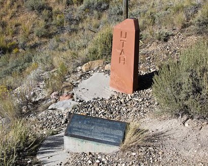 |
| Triple point monument |
Another five quiet miles passed and I noticed a tattered
makeshift plywood sign mounted on a fence post with “Monument Road” scribed on
it. The single-lane dirt road led up a
hollow into the Boundary Ridge wilderness where one can find a survey monument marking
a point common to the three states of Idaho, Utah and Wyoming. I thought, “Now that’s where I want to go
before leaving Cokeville.” But, judging from
the condition of the road, a four-wheel drive vehicle was recommended. Oh well, maybe another day. Besides, I don’t believe it would be as
impressive as the southwest’s Four Corners Monument.
I had been counting the miles since leaving Cokeville,
and before I knew it, the half-way point appeared on the horizon. At the turn-around point, I noticed several
cans of OFF placed on a table adjacent to a five-gallon Igloo water dispenser
with a few one-gallon water jugs packed into a cardboard box placed on the
ground underneath. I guess other runners
failed to adequately prepare themselves and weren’t mindful of the mosquitos in
the area.
The number of mosquitos seemed to wane as the morning
progressed and weren’t so active and bothersome with the rising temperatures. I wanted more OFF as some insurance, but as I
went to use a can, each one was empty! I
wasn’t too concerned though. I refilled
my small eight-ounce plastic containers and began the final half.
The second half of the marathon began slow and steady,
passing some of the early start runners and walkers. As the temperatures warmed and the sun
becoming more intense as it neared the zenith, my pace slowed even more. Around Marathon Mile 16, I had to resort to a
run-walk-run program. With the final ten
miles, I was beginning to feel it.
Whether it was a result of my body fining the proper
balance of oxygen to counter the lactic acid buildup in my muscles or a
temporary endorphin production, I would get occasional second winds making
running less demanding. Nevertheless, I
was so looking forward to finishing. Enjoying
the scenery was furthest from my mind as I directed my focus towards
Cokeville.
Runners I passed a few miles back were passing
me. I guess some recognized me and provided
bits of encouragement. Were the words
“struggling, please help” hanging over my head?
Rounding the final curve over the brow of a hill, I
saw that little grouping of trees that provided the final shade for the first
half of the course. A woman runner holding
a leash fixed to her golden retriever passed me and said some words of
inspiration to get me over the final hump.
Her running looked so easy and relaxed – not to mention her dog trotting
along like it was nothing. It looked to
me that her spectator husband handed over the dog while he finished the final
mile or so with her.

I ran to the trees and took a little walk break in the
shade. For that momentary reprieve, I
mustered up the energy for the final half-mile push to the finish line.
I rounded the corner on to West Main Street and saw
the finish line gantry in the distance just beyond the railroad tracks. I crossed in a time of 5:04:26, about a minute
faster than my Idaho time (considering Idaho was short).
My Garmin measured slightly over 26.2 miles. In a way, a noticeable improvement from the
Idaho marathon.
Age
graded score: 46%
Age
graded time: 4:35:44
Median
finish time: 5:30:05
I walked to the park’s arbor to pick up my finisher’s
medal, had some water and chowed down several food items to refuel my depleted
self while taking a load off, joyful of the fact I was able to check off
another two states.
At times, I would hear several criticisms about the
altitude of Wyoming. For me, I don’t
believe it had much of an effect on my performance. The sole reason for my slower times was likely
the combination of the heat and the sun.
The elevation nay have played a part, but overall, I didn’t feel it was
since I am a finely tuned and well-oiled machine. Some may disagree with that self-assessment;
however.
 |
| Bear Lake overlook off US 89 |
After a few pictures of our successful Bear Lake
experience, we changed out of our wet clothes and moseyed on down the highway
to visit with my aunt and uncle in Logan; in the meantime, stopping at Merlin’s
Drive-in in Laketown for a delicious burger and a frozen milkshake concoction –
hey, we earned it! Our original intent
was to stop at the Bear Trapper Restaurant in Garden City (we ate there Saturday),
but it was closed on Sundays. Looking
for some good food? Try it.
US Highway 89 links Bear Lake with Logan. Along US 89, we found a wide spot traversing
a grassy prairie along the road in the upper regions of Logan Canyon to soak
our achy and tired feet in the icy waters of the Logan River not far from
Beaver Mountain Ski Area. Frankly, I
didn’t think the water was going to be so cold – wrong! I
could only muster a few seconds in the cold water, but my wife seemed to have a
better tolerance.
Following a great visit and overnight stay with a
well-deserved relaxing respite in Logan, it was back to Salt Lake City to visit
one of my cousins and her family.
My wife and I had a few hours to spare while in Salt
Lake City, so to occupy our time, we enjoyed the spectacular sunny day visiting
and touring the state capitol building and enjoying the weather walking through
the picturesque Memory Grove Park. The
day brought many folks to the park - some walking their dogs, some jogging the
Freedom Trail alongside the tranquil sounds of City Creek or some just enjoying
a picnic meal – in any event, it was a picture perfect day. I would have loved to jog the trail to cavort
with nature, but after 52 miles, I thought my legs had enough.

 |
| City Creek tranquility |
We made our way up the hill to my cousin’s house in
the SLC area who was as busy as always.
We decided to caravan up Little Cottonwood Canyon to the Snowbird Ski
Area and ride their tram to the top of Hidden Peak.
 |
| Snowbird Aerial Tram |
I last skied Snowbird and Alta (just up the road, by
the way) back in the 1980s, but I’ve never seen the canyon during the summer
when the slopes are devoid of snow. With
the endless activities in the area, I thought what an awesome place it would be
to plan a summer get-away.
Remnants of the granular, course and slushy winter
snowpack still blanketed parts of the 11,000-foot peak where views of the Heber
Valley to the southeast and the Salt Lake Valley to the west were spectacular
on such a bright sunny day, albeit a little chilly. Making snowballs with that slushy snow was
definitely a challenge.
We took the final tram of the day off the peak back to
the base station. To satiate our
appetites, we all sat down in the resort area commons to dine on a custom
packed meal my cousin had prepared. I
enjoyed watching the kids chase squirrels while having a good time burning off
the energy of youth. We were even lucky
enough (while maintaining our distance) to witness a young moose promenading through
the resort’s parking lot.
Unfortunately, darkness was beginning to rule the day
and time got the better of us which forced to part ways. We made our way back down the canyon into Salt
Lake City to ready ourselves for an early morning flight back to LAX.

No comments:
Post a Comment